Cornforth Consultants
  • Home
  • Services
    • Earth & Rockfill Dams
    • Reservoirs, Canals, and Levees
    • Spillway Safety Inspections
    • Landslides and Rockfall
    • Earthquake Engineering
    • Geologic Hazards
    • Geotechnical Site Characterization
    • Hydrogeology
    • Expert Witness
    • Concrete Dams and Locks
    • Geotechnical Instrumentation
    • Deep and Shallow Foundations
    • Geotechnical Manuals
  • Industries
    • Water Resources
    • Energy
    • Natural Resources
    • Industrial
    • Transportation
    • Ports and Airports
    • Expert Witness
  • Projects
    • Earth and Rockfill Dams >
      • Barney Reservoir
      • Frog Lake Reservoir
      • Iron Gate Dam Raise
      • McGuire Dam Raise
      • Bonneville Cofferdam
      • Bull Run No. 2 Seismic Stability Analysis
    • Levees and Canals >
      • Libby Dike Rehab.
      • St. Johns Dike Stabilization
      • Cowlitz River Levees
      • Swift Canal Failure
    • Earthquake Engineering >
      • Barney Dam Seismic Analysis
      • Fern Hill WTP Liquefacation Study
      • Bull Run No. 2 Seismic Stability Analysis
      • Mt. Tabor Seismic Stability Analysis
      • Port Westward Power Plant Seismic Design
    • Rock Slopes and Tunnels >
      • Libby Rockfall Mitigation
      • Sandy River Pipeline Tunnels
      • Ketchikan Third Avenue Extension
      • Sain Creek Water Supply Tunnel
      • Montana Rockfall Hazard Rating System
    • Foundations >
      • Port Westward Power Plant
      • Cascade Locks Casino
      • Air National Guard Hangar
      • Biglow Canyon Windfarm
      • Oakridge Water System Improvements
    • Concrete Dams and Locks >
      • John Day Lock & Dam
      • Marmot Dam Removal
      • The Dalles Dam
      • Willamette Falls Dam
      • Bonneville Dam
    • Transportation >
      • OTIA Cracked Bridge Geotechnical Baselines
      • Newburg Dundee Bypass Design DEIS
      • I-84 Sandy River Bridge Investigation
      • Tanana River Bridge Foundation, Tok, Alaska
      • Montana RHRS Implementation
      • Ketchikan Third Avenue Extension
    • Ports and Airports >
      • Navy CVN Drydock
      • Depoe Bay Seawall Distress
      • Willamette Falls Flow Control Structure
      • Air National Guard Hangar
    • Water and Wastewater >
      • Fern Hill Water Treatment Plant
      • Tualatin Valley North Transmission Line
      • Evaluation of 28 Water Storage Facilities
      • City of Sandy Water Treatment Plant
      • Mt. Tabor Reservoir No. 5 Cap Study
      • Oakridge Water System Improvements
  • Staff
  • Resources
  • Careers
    • Geotechnical Engineer
  • Contact Us

Mt. Tabor Reservoir Replacement

Portland, Oregon
As part of a Federal requirement to improve the reliability and safety of drinking water for major metropolitan areas, the Portland Water Bureau began developing designs to replace the open reservoirs at Mt. Tabor with buried reservoirs. The project would involve decommissioning Reservoir No. 1, constructing a rectangular 50 MG concrete reservoir within the existing Reservoir No. 5 footprint, and constructing a rectangular 20 MG concrete reservoir in the northern half of the existing Reservoir No. 6 footprint. Shallow, reflective ponds would be constructed above the reservoirs to maintain the appearance of the original “open” reservoirs. The geotechnical exploration program included 15 mud-rotary borings and 15 geoprobe holes.

Soft compressible silt and clay was encountered beneath Reservoir 5. Several options were provided to minimize potential differential settlement of the proposed 50 MG tank including overexcavation and backfilling with crushed rock, founding the structure on a concrete mat, using deep piles, or improving the strength of the silt and clay using specialized construction stone columns or jet grouting.

​The borings near Reservoir 6 encountered loose to medium dense sand overlying stiff clayey silt. Seismic liquefaction analyses indicated that the majority of the sand deposit has adequate factors of safety against liquefaction. Geotechnical foundation recommendations were provided for shallow spread footings founded on a concrete membrane slab. Recommendations were also provided at both reservoir sites for base slabs, subdrain systems, temporary cut slopes, lateral earth pressures, site grading, fill placement, and seismic ground response.
Type 2 RHRS Slope on Highway 26
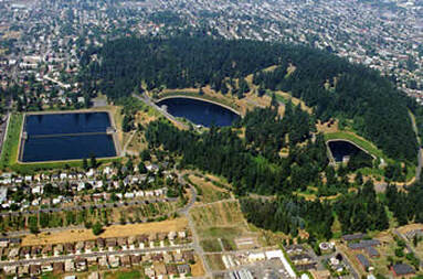
Mt. Tabor Reservoir Complex

​Services Provided:

  • Review of available geology, geotechnical data and historic reports
  • Evaluate data gaps
  • Develop plan of explorations
  • Subsurface drilling and geoprobe investigation
  • Soil sampling and laboratory testing
  • Assessment of geotechnical material characteristics
  • Evaluation of foundation options
  • Analysis of potential differential settlement
  • Seismic liquefaction analysis
  • Evaluation of ground improvement options
  • Develop foundation recommendations
  • Geotechnical recommendations for reservoir burial
  • Geotechnical report
  • Home
  • Services
    • Earth & Rockfill Dams
    • Reservoirs, Canals, and Levees
    • Spillway Safety Inspections
    • Landslides and Rockfall
    • Earthquake Engineering
    • Geologic Hazards
    • Geotechnical Site Characterization
    • Hydrogeology
    • Expert Witness
    • Concrete Dams and Locks
    • Geotechnical Instrumentation
    • Deep and Shallow Foundations
    • Geotechnical Manuals
  • Industries
    • Water Resources
    • Energy
    • Natural Resources
    • Industrial
    • Transportation
    • Ports and Airports
    • Expert Witness
  • Projects
    • Earth and Rockfill Dams >
      • Barney Reservoir
      • Frog Lake Reservoir
      • Iron Gate Dam Raise
      • McGuire Dam Raise
      • Bonneville Cofferdam
      • Bull Run No. 2 Seismic Stability Analysis
    • Levees and Canals >
      • Libby Dike Rehab.
      • St. Johns Dike Stabilization
      • Cowlitz River Levees
      • Swift Canal Failure
    • Earthquake Engineering >
      • Barney Dam Seismic Analysis
      • Fern Hill WTP Liquefacation Study
      • Bull Run No. 2 Seismic Stability Analysis
      • Mt. Tabor Seismic Stability Analysis
      • Port Westward Power Plant Seismic Design
    • Rock Slopes and Tunnels >
      • Libby Rockfall Mitigation
      • Sandy River Pipeline Tunnels
      • Ketchikan Third Avenue Extension
      • Sain Creek Water Supply Tunnel
      • Montana Rockfall Hazard Rating System
    • Foundations >
      • Port Westward Power Plant
      • Cascade Locks Casino
      • Air National Guard Hangar
      • Biglow Canyon Windfarm
      • Oakridge Water System Improvements
    • Concrete Dams and Locks >
      • John Day Lock & Dam
      • Marmot Dam Removal
      • The Dalles Dam
      • Willamette Falls Dam
      • Bonneville Dam
    • Transportation >
      • OTIA Cracked Bridge Geotechnical Baselines
      • Newburg Dundee Bypass Design DEIS
      • I-84 Sandy River Bridge Investigation
      • Tanana River Bridge Foundation, Tok, Alaska
      • Montana RHRS Implementation
      • Ketchikan Third Avenue Extension
    • Ports and Airports >
      • Navy CVN Drydock
      • Depoe Bay Seawall Distress
      • Willamette Falls Flow Control Structure
      • Air National Guard Hangar
    • Water and Wastewater >
      • Fern Hill Water Treatment Plant
      • Tualatin Valley North Transmission Line
      • Evaluation of 28 Water Storage Facilities
      • City of Sandy Water Treatment Plant
      • Mt. Tabor Reservoir No. 5 Cap Study
      • Oakridge Water System Improvements
  • Staff
  • Resources
  • Careers
    • Geotechnical Engineer
  • Contact Us