Water Supply Tunnels Crossing Sandy River
Sandy, Oregon
|
The primary water supply for 800,000 people in the Portland metropolitan comes from the Bull Run Watershed through three large-diameter pipelines. Sandy River, a natural barrier to the three conduits, is crossed with two bridges, which expose the supply to natural hazards including earthquakes, volcanic debris flows, landslides, forest fires and wind and ice storms. Cornforth Consultants was retained by the City of Portland Bureau of Water Works to determine the feasibility of relocating the existing and future conduits into underground crossings at the river.
The site geology and natural hazards were mapped and evaluated, and geotechnical explorations were performed with vertical and angled borings drilled deep into rock. Rock samples were collected and tested to determine the rock mass characteristics, and permeability tests were performed to estimate the flow of groundwater through the fractured rock. Environmentally sensitive exploration methods were used to protect the wild and scenic Sandy River and included helicopter access and pontoon-barges, and low-impact mobile drilling rigs. Cornforth Consultants and the design team conceptualized cut-and-cover and bored tunnel options for the City of Portland Water Bureau to identify an environmentally sensitive and cost effective tunneling technique. After a tunneling option was identified, Cornforth performed preliminary geotechnical engineering. Preliminary engineering phase included site specific subsurface explorations, geophysical testing, laboratory testing and rock mass classification and seismic considerations. Geophysical testing included ground penetrating radar, acoustic sub bottom profiling and electrical resistivity imaging to supplement drill hole data. Laboratory testing of rock conditions was conducted along with the rock core sampling to develop Rock Quality Designation (RQD), Rock Mass Rating (RMR), and Rock Mass Quality (Q) characterization. Seismic hazards were evaluated to include regional fault sources and the Sandy River Fault Zone. Ground motion parameters of peak horizontal (particle) velocity and shear wave velocity were also assessed. Foundation design consisted of evaluating potential seepage into the tunnels, and constructability of large concrete shafts at each end of the tunnel crossings. |
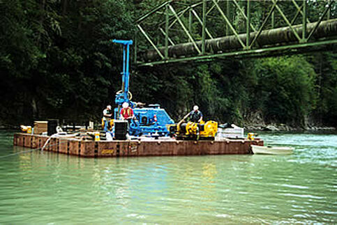
Overwater Drilling and Sampling
Services Provided:
|