Mount Tabor Seismic Stability Analysis
Portland, Oregon
|
The Mount Tabor reservoir complex was built between 1894 and 1911 and was an integral part of the City of Portland’s water supply system. The Mount Tabor complex includes dam No.'s 1, 5, and 6. The dam at Reservoir No. 1 is a 30-foot high concrete structure with a downstream earthfill buttress. The dam at Reservoir No.5 is similar but 55 feet high. Both are built on the upper slopes of Mount Tabor, a dormant volcanic vent. The dam enclosing Reservoir No. 6 is an earth embankment 2,100 feet long and up to 28 feet high. The complex includes the ability to generate power from the 110 feet of head between Reservoirs No. 5 and No. 6.
The foundation below the embankment dam at Reservoir No. 6 contains clean, alluvial sand deposits, 14 to 47 feet thick. A FERC dam safety study raised concern about potential liquefaction of the foundation sands. Cornforth Consultants was retained by the Portland Water Bureau to assess the liquefaction hazard and risk posed to the reservoirs. The study included 19 exploratory borings to evaluate soil type and density; gradation testing to determine silt content; a probabilistic seismic hazard evaluation to develop the design earthquake; a finite element analysis to determine in-situ stresses below the embankment; and an assessment of cyclic stresses within the foundation. The results of the analyses determined that localized pockets of foundation sand could liquefy; however, the vulnerable pockets were isolated and not laterally continuous. Therefore; excess pore-water pressures generated in the localized pockets would dissipate into denser soil without threatening the stability of the embankment. |
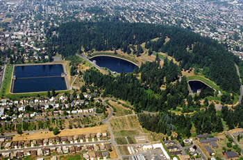
Mount Tabor Reservoirs
Services Provided:
|