Cornforth Consultants
  • Home
  • Services
    • Earth & Rockfill Dams
    • Reservoirs, Canals, and Levees
    • Spillway Safety Inspections
    • Landslides and Rockfall
    • Earthquake Engineering
    • Geologic Hazards
    • Geotechnical Site Characterization
    • Hydrogeology
    • Expert Witness
    • Concrete Dams and Locks
    • Geotechnical Instrumentation
    • Deep and Shallow Foundations
    • Geotechnical Manuals
  • Industries
    • Water Resources
    • Energy
    • Natural Resources
    • Industrial
    • Transportation
    • Ports and Airports
    • Expert Witness
  • Projects
    • Earth and Rockfill Dams >
      • Barney Reservoir
      • Frog Lake Reservoir
      • Iron Gate Dam Raise
      • McGuire Dam Raise
      • Bonneville Cofferdam
      • Bull Run No. 2 Seismic Stability Analysis
    • Levees and Canals >
      • Libby Dike Rehab.
      • St. Johns Dike Stabilization
      • Cowlitz River Levees
      • Swift Canal Failure
    • Earthquake Engineering >
      • Barney Dam Seismic Analysis
      • Fern Hill WTP Liquefacation Study
      • Bull Run No. 2 Seismic Stability Analysis
      • Mt. Tabor Seismic Stability Analysis
      • Port Westward Power Plant Seismic Design
    • Rock Slopes and Tunnels >
      • Libby Rockfall Mitigation
      • Sandy River Pipeline Tunnels
      • Ketchikan Third Avenue Extension
      • Sain Creek Water Supply Tunnel
      • Montana Rockfall Hazard Rating System
    • Foundations >
      • Port Westward Power Plant
      • Cascade Locks Casino
      • Air National Guard Hangar
      • Biglow Canyon Windfarm
      • Oakridge Water System Improvements
    • Concrete Dams and Locks >
      • John Day Lock & Dam
      • Marmot Dam Removal
      • The Dalles Dam
      • Willamette Falls Dam
      • Bonneville Dam
    • Transportation >
      • OTIA Cracked Bridge Geotechnical Baselines
      • Newburg Dundee Bypass Design DEIS
      • I-84 Sandy River Bridge Investigation
      • Tanana River Bridge Foundation, Tok, Alaska
      • Montana RHRS Implementation
      • Ketchikan Third Avenue Extension
    • Ports and Airports >
      • Navy CVN Drydock
      • Depoe Bay Seawall Distress
      • Willamette Falls Flow Control Structure
      • Air National Guard Hangar
    • Water and Wastewater >
      • Fern Hill Water Treatment Plant
      • Tualatin Valley North Transmission Line
      • Evaluation of 28 Water Storage Facilities
      • City of Sandy Water Treatment Plant
      • Mt. Tabor Reservoir No. 5 Cap Study
      • Oakridge Water System Improvements
  • Staff
  • Resources
  • Careers
    • Geotechnical Engineer
  • Contact Us

Newburg - Dundee Bypass Design Draft Environmental Impact Statement

Newburg, Oregon
The Oregon Department of Transportation (ODOT) completed a bypass route for Highway 99W and OR-18 to improve traffic near Newberg and Dundee and to integrate it with an existing bypass around McMinnville. Cornforth Consultants (CCI), as a member of the Parametrix team, was retained to assist ODOT with the planning process and environmental impact statements.

Geologic reconnaissance and preliminary subsurface explorations were performed. The new highway route crosses low-lying areas underlain by silt and sand alluvium. The groundwater is relatively shallow with seasonal highs near the ground surface. CCI evaluated the relative risks and consequences of geologic conditions along the proposed route. Challenges for construction and operation of the highway include:
​
  • Saturated conditions can liquefy during seismic events, which could require ground improvement mitigation where the soils are relatively loose at bridge crossing locations.
  • Excavations for the roadway would be impacted by high groundwater and seepage, and unusual drainage systems would be required for depressed roadway sections.
  • The reuse of excavated wet soils would require extraordinary treatment to be placed in roadway embankments. Imported fill could be necessary and excess wet soil quantities would need disposal sites.
  • Existing landslides and old landfill and sawdust fill areas would need to be mitigated or avoided.
  • Slope stability near stream crossings is marginal and therefore earthwork setbacks and ground improvement methods are likely to avoid causing slope failures.
  • Construction of tall embankments could cause unacceptable settlements and marginal slope stability, and therefore mitigation could be necessary if heights exceed 20 feet.

​CCI provided recommendations for optimizing the horizontal and vertical alignment of the new highway within the designated corridor. CCI also presented geotechnical findings and recommendations at several project and public meetings.
Type 2 RHRS Slope on Highway 26
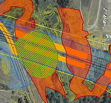
Geotechnical Mapping for a Bypass Segment

​Services Provided:

  • Review available geology and geotechnical information
  • Reconnaissance for geotechnical conditions and geologic hazards
  • Develop geotechnical condition maps with groundwater and landslide hazards
  • Recommendations for phase 1/advance investigations
  • Assess slope and landslide stability
  • Assess groundwater conditions for stability and construction
  • Assess potential seismic liquefaction
  • Assess balanced cut and fill construction
  • Recommendations for highway alignment
  • Home
  • Services
    • Earth & Rockfill Dams
    • Reservoirs, Canals, and Levees
    • Spillway Safety Inspections
    • Landslides and Rockfall
    • Earthquake Engineering
    • Geologic Hazards
    • Geotechnical Site Characterization
    • Hydrogeology
    • Expert Witness
    • Concrete Dams and Locks
    • Geotechnical Instrumentation
    • Deep and Shallow Foundations
    • Geotechnical Manuals
  • Industries
    • Water Resources
    • Energy
    • Natural Resources
    • Industrial
    • Transportation
    • Ports and Airports
    • Expert Witness
  • Projects
    • Earth and Rockfill Dams >
      • Barney Reservoir
      • Frog Lake Reservoir
      • Iron Gate Dam Raise
      • McGuire Dam Raise
      • Bonneville Cofferdam
      • Bull Run No. 2 Seismic Stability Analysis
    • Levees and Canals >
      • Libby Dike Rehab.
      • St. Johns Dike Stabilization
      • Cowlitz River Levees
      • Swift Canal Failure
    • Earthquake Engineering >
      • Barney Dam Seismic Analysis
      • Fern Hill WTP Liquefacation Study
      • Bull Run No. 2 Seismic Stability Analysis
      • Mt. Tabor Seismic Stability Analysis
      • Port Westward Power Plant Seismic Design
    • Rock Slopes and Tunnels >
      • Libby Rockfall Mitigation
      • Sandy River Pipeline Tunnels
      • Ketchikan Third Avenue Extension
      • Sain Creek Water Supply Tunnel
      • Montana Rockfall Hazard Rating System
    • Foundations >
      • Port Westward Power Plant
      • Cascade Locks Casino
      • Air National Guard Hangar
      • Biglow Canyon Windfarm
      • Oakridge Water System Improvements
    • Concrete Dams and Locks >
      • John Day Lock & Dam
      • Marmot Dam Removal
      • The Dalles Dam
      • Willamette Falls Dam
      • Bonneville Dam
    • Transportation >
      • OTIA Cracked Bridge Geotechnical Baselines
      • Newburg Dundee Bypass Design DEIS
      • I-84 Sandy River Bridge Investigation
      • Tanana River Bridge Foundation, Tok, Alaska
      • Montana RHRS Implementation
      • Ketchikan Third Avenue Extension
    • Ports and Airports >
      • Navy CVN Drydock
      • Depoe Bay Seawall Distress
      • Willamette Falls Flow Control Structure
      • Air National Guard Hangar
    • Water and Wastewater >
      • Fern Hill Water Treatment Plant
      • Tualatin Valley North Transmission Line
      • Evaluation of 28 Water Storage Facilities
      • City of Sandy Water Treatment Plant
      • Mt. Tabor Reservoir No. 5 Cap Study
      • Oakridge Water System Improvements
  • Staff
  • Resources
  • Careers
    • Geotechnical Engineer
  • Contact Us